Announcement

Community Health Maps Webinar Series

In August 2020 Community Health Maps is partnering with the University of Michigan Libraries to present a short webinar series. These will be live presentations followed by a Q & A session. They will also be recorded and available afterwards via YouTube.

Mapping COVID-19 with QGIS

August 14, 2020

This one hour webinar teaches how to map the COVID-19 pandemic using free data and open source software. The presentation begins with an introduction to Community Health Maps, a program to empower underserved populations with free mapping tools. Community Health Maps case studies will demonstrate the successful use of these tools. The remainder focuses on downloading and mapping COVID-19 data using QGIS, the world’s leading open source desktop GIS software. By the end of the webinar you will know how to download data, import the data into QGIS, symbolize it, and make a map of COVID-19 cases per one million people by county. This webinar will be recorded and made available via YouTube.

REGISTER HERE

Layout 1.jpg

Collecting Field Data Using Free and Open Source Software:
Input and QGIS

August 21, 2020

There are two new options for field data collection related to QGIS named Input/Mergin and QField, and both will be introduced in this webinar. Each app runs on both iOS and Android. Since they are free to use, offer great functionality, and can be used on any platform, they are the recommended field data collection apps for Community Health Mappers. Due to time constraints, this webinar will focus on Input. You will see how to set up a typical data collection form using QGIS. You will also learn to use the Mergin plugin to move data back and forth between a computer and a mobile device. Sample data will be collected and Mergin will again be used to bring the data into QGIS where we’ll map it. This webinar will be recorded and made available via YouTube.

REGISTER HERE

Input on iOS!

The previous post covered a promising new tool named Input for data collection. As a reminder, this tool involves setting up a QGIS project and using the Mergin plugin to transfer the project and data to and from your computer and smartphone. It is also a free app. Another aspect of Input is that until now it has only been available for Android.Yesterday Lutra Consulting announced the release of the beta version for iOS. It is available via an app named TestFlight!From there is can be used just as was described in the previous post where setting up a project, using Mergin and collected data with Input was described. Once I have had a chance to experiment with it I will follow up with a summary on that. In the meantime, if you are an Apple iOS user, download the app and follow the previous post to give it a trial run.

Discover QGIS 3.x - A Workbook for Classroom or Independent Study

Today Discover QGIS 3.x was published by Locate Press. Authored by Community Health Mapper Kurt Menke, this is an update of the original title, using QGIS v3.6 and covering spatial analysis, data management, and cartography. It is designed to teach mapping and GIS using QGIS. As such it begins with basics. It is a comprehensive up-to-date workbook built for both the classroom and professionals looking to build their skills.It is designed to take advantage of the latest QGIS features, and will guide you in improving your maps and analysis.The book is a complete resource and includes:

  • Lab exercises
  • Challenge exercises
  • All data, discussion questions, and solutions

What's new in this edition:

  • Updated to QGIS 3.6
  • Fifteen new exercises
  • A new section, Advanced Data Visualization, covering:
    • Blending modes
    • Live layer effects
    • Geometry generators
    • Rendering Points
    • Time Manager
    • Native 3D
    • Mesh data
  • Appendices covering:
    • Keyboard shortcuts
    • Useful Plugins
    • Getting involved

To see what's included in the book, download the Table of Contents (PDF). Discover QGIS 3.x is available in color as an ebook or paper back.2nd_ed_draft_covercropped

QGIS 3.6 Noosa Released!

This past weekend QGIS 3.6 Noosa was released as the next stable release. You can visit the QGIS download site to find installers for Windows, Mac and Linux.f335c2ee37b714ad6eec143246d947f09a5ff2f1At the same time QGIS 3.4 Madeira became the latest long-term release. This means that version 3.4 will be supported for a calendar year with bug fixes. This is now the version you should install and  work with for the next year.D0PBNsOXcAAgwDcIf you have not yet worked with the new 3.x line you can look at the visual changelogs here: Version 3.0Version 3.2 - Version 3.4. In general the QGIS 3.x line is a major upgrade from 2.x. I encourage you to install it and make a map!
A Preview of Coming Attractions

2019 is off to a fast start with the Community Health Maps program!The QGIS portion of the CHM labs found on the Resources page are being updated. Look for these in the next several weeks. These were last updated in 2017. In one month a new long-term release of QGIS will be released: QGIS 3.6. This will be the first long-term release of the 3.x line. If you have not yet switched over to QGIS 3.x, March will be the time to do so.  At this time 2.x line will be officially retired. You can revisit last years blog about what's new in QGIS 3 to see the sort of features now available. I will be posting an post next month about what you need to know about QGIS 3.6, as well as an announcement when the new training materials have been completed.There are a series of QGIS workshops scheduled for the spring:April 2 - University of Michigan Ann ArborApril 3 - University of Michigan FlintApril 4 - University of Michigan Detroit CenterApril 5 - University of Michigan DearbornMay 14 - Rising Voices 7 - Converging Voices: Building relationships and practices for intercultural science. - Boulder ColoradoJune 3-7 - ASTHO Climate and Health SummitJune 17-21 - ASTHO CHM and Vector Borne Disease WorkshopHappy Mapping! I hope to see you in the new year!   

QGIS 3.4 Released!

splash34vs.png

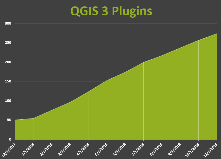
On November 2nd QGIS 3.4 'Madeira' was released. It is the first long-term release in the new 3.x platform.  To install it you can visit the QGIS Download page. Installers are ready for Windows, Max OSX and Linux.QGIS VERSIONSRemember QGIS always has two main versions available. There is the long-term release, which is the most stable because it is supported for one calendar year. In addition there is always a latest release. QGIS 3.4 falls into this former category.QGIS 3.4This is a great time to update your version of QGIS. Especially if you are still using the 2.x line. QGIS 3.x is fast, stable and feature rich. If you are still a 2.x user there is a huge list of new features and useful changes. At this point most of the popular plugins have been migrated over from 2.x to 3.x. The chart below shows the steady migration and growth of 3.x plugins. You can review the visual changelog for this version here. You can also find the changelogs for versions 3.0 and 3.2.Plugins11-1_18

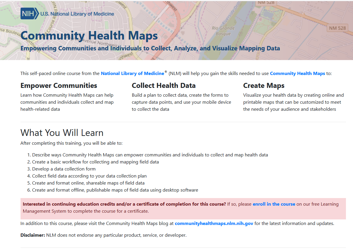
Try Out the New Community Health Maps (CHM) Online Tutorial!

By Colette HochsteinA Community Health Maps (CHM) online tutorial is now available. It is a free, self-paced online course from the National Library of Medicine (NLM), which provides guidance on using low cost mapping tools to collect, analyze, and visualize mapping data.Community Health Maps seeks to empower communities and individuals by helping them collect and map health-related data. The CHM tutorial helps users build a plan to collect data, create forms to capture data points, and use mobile devices to collect data. The CHM tutorial can also aid in creating online and printable maps that can be customized to meet the needs of specific populations and stakeholders.The tutorial covers how to create a basic workflow for collecting and mapping field data via step-by-step instructions on how to (1) develop a data collection form, (2) collect field data according to the data collection plan, (3) create online dynamic maps of the data collected, and (4) create static offline publishable maps of field data using desktop software.As a bonus, this course provides continuing education credit (CE), including through the Medical Library Association (MLA, http://www.medlib-ed.org/products/1847/community-health-maps), and/or a certificate of completion. For continuing education credits and/or a certificate of completion, please enroll in the course on the free Learning Management System (LMS).OnlineTutorialIf you are new to Community Health Maps, and are not sure how this mapping workflow can benefit you and your organization, you can search this blog for case studies. In particular you may want to look at the selected case studies linked to below. Read about how students and professionals have used Community Health Maps:


The Carto Grant Program

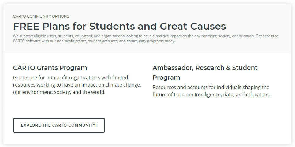
Carto, the platform for making online maps, recently abandoned it's free license option. The reason they gave was that many users were creating accounts, sometimes several accounts, and simply not using them. This became expensive overhead for them to manage. As a result they now offer a Professional or Enterprise plan once your free trial expires. This new pricing scheme is shown below:2018-07-11_115705Note that non-profit organizations receive a 20% discount off this Professional license. This license also affords you many more benefits than the previous free license.  For example, the free license gave you 50Mb of cloud storage space while the Professional plan gives you 500Mb. It also allows you to set permissions on your datasets to make them private. It also gives you email and online support.If that price is beyond your organizations budget you will notice that directly below the pricing plan is a section covering FREE Plans for Students and Great Causes! 2018-07-11_120555.jpgCarto has a grant program. You can read about this program here. All it takes to apply is filling out an application form!
QGIS 3 Released!

qgis-logo_anita02-e1517416917170.png

On February 23rd QGIS 3 was formally released. Since then the developers have been working on completing installers for Windows, Mac and Linux. As of yesterday the software is ready to be installed on every operating system! To install it you can visit the QGIS Download page.QGIS VERSIONSQGIS always has two main versions available. There is the long-term release, which is the most stable because it is supported for one calendar year. In addition there is always a latest release. QGIS 3 falls into this latter category, it is the latest release. At the moment the long-term release is version 2.18. The latest release is still considered stable, but a new one comes out every 4 months.WHICH VERSION TO CHOOSE?If you want to have one version of QGIS without having to worry about updates, use the long-term release (2.18). If you want to experience all the new features that come with version 3 you will want the latest release (3.0). As mentioned last month, version 3 is a major new release with a lot of changes and new features.On Windows machines you can have both. You can easily install both versions of QGIS side by side with no conflicts by using the OSGeo4W Network Installer. On Mac and Linux machines you can only have one version, so you need to choose.QGIS 3QGIS 3 is fast, stable and feature rich. The main issue for many users is that not all Plugins have yet  to be ported to QGIS 3. This is because this responsibility falls onto the individual plugin authors. With that said, at last count there were already 117 plugins available for version 3.